Nous utilisons des cookies pour améliorer votre expérience. Pour nous conformer à la nouvelle directive sur la vie privée, nous devons demander votre consentement à l’utilisation de ces cookies. En savoir plus.
Le Canal du Midi de long en large
Valentin - EAN : 9782746645189
Édition papier
EAN : 9782746645189
Paru le : 31 mai 2012
18,00 €
17,06 €
Bientôt disponible
Pour connaître votre prix et commander, identifiez-vous
Manquant provisoirement
Notre engagement qualité
-
 Livraison gratuite
en France sans minimum
de commande -
 Manquants maintenus
en commande
automatiquement -
 Un interlocuteur
unique pour toutes
vos commandes -
 Toutes les licences
numériques du marché
au tarif éditeur -
 Assistance téléphonique
personalisée sur le
numérique -
 Service client
Du Lundi au vendredi
de 9h à 18h
- EAN13 : 9782746645189
- Réf. éditeur : 01CANALDUMID
- Editeur : Valentin
- Date Parution : 31 mai 2012
- Disponibilite : A reparaître
- Barème de remise : NS
- Format : H:213 mm L:137 mm E:13 mm
- Poids : 210gr
-
Résumé :
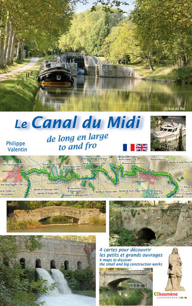
Les 4 cartes inédites de ce coffret vous invitent à explorer un incroyable ouvrage. Pliées, elles se consultent comme un livret. Dépliées, côte à côte, elles révèlent de façon ludique toute l’ampleur du Canal du Midi. De ses prises d’eau jusqu’à ses extrémités, de Riquet et Vauban jusqu’à nos jours, l’œuvre est bien plus qu’un superbe chemin ombragé. Des constructions discrètes ou audacieuses, innovantes ou normalisées évoquent la gestion des flux et leurs divers usages, le délicat franchissement des eaux sauvages, les hommes au service du canal et les étapes des barques de poste. Vous serez impressionnés par des chantiers colossaux et surpris par les défis techniques qu’ont relevés les ingénieurs, architectes, maçons et topographes. Les voûtes des aqueducs, le galbe d’un déversoir, vannes et siphons cachés, épanchoirs, ponts-canaux… témoignent de leur maîtrise. Observez la forme des écluses, les matériaux ou le dessin des ponts évoluant au fil de l’eau et des époques. Imaginez l’effervescence des ports et l’animation des lavoirs. Agrémentées de 158 textes et histoires, de 258 photographies et anciens plans, vos balades en bateau, à pied ou à vélo prendront une nouvelle dimension et les cartes paysagères en prolongeront longtemps le plaisir. Bon voyage, ouvrez l’œil.
The four original maps in this package will enable you to explore an incredible construction work. They have been folded in two in order to be consulted as you would a booklet. Once unfolded and placed next to each other, these ludic maps unveil the entire scope of the Canal du Midi. From its water intakes to its boundaries, from Riquet and Vauban’s time to today, this route is more than just a magnificent shaded path. Discrete or audacious, innovative or standardized, this project reminds us of how the flow of water was managed and what it was used for ; as well as how tricky it was to organize the crossings of the wild waters. It also evokes the people who worked and lived along the canal and the various legs of the route undertaken by the barges. You will be impressed by the colossal construction sites and surprised to discover all the technical challenges taken up by the engineers, the architects, the bricklayers and the topographers. The archways of the aqueducts, the curves of the reservoirs, the hidden sluice gates and siphons, the discharge channels, the canal-bridges … are all proof of how well these different protagonists mastered their know-how. Pay attention to the shape of the locks, to the materials used and to the design of the bridges which have changed over the years and according to the flow. Try to imagine how busy and exiting life was on the harbors and around the wash-houses. Thanks to the various texts and stories (158) and to the pictures and old maps (258) included in this package, your boat trips, your strolls or your bike rides will take on a whole different meaning. In addition, the maps of the landscape will enable you to savor these moments forever
